
Scientific Methodology
Every project follows a rigorous analytical workflow — from data acquisition to validated output.
Advanced engineering solutions in GIS, topographic surveying, and remote sensing.
Every project follows a rigorous analytical workflow — from data acquisition to validated output.
InSAR, multispectral, and LiDAR data processed with industry-standard pipelines.
Spatial analysis and modeling that supports planning, risk assessment, and infrastructure design.
Deep understanding of Egypt and MENA context, aligned with international engineering practice.
ElGharbawigeo is a specialized geospatial consulting firm focused on critical analysis and decision-making for national and high-value projects. We combine geoinformatics, AI, and advanced geospatial data collection techniques—including remote sensing, LiDAR, InSAR, and topographic surveying—to deliver engineering-grade insights that support infrastructure planning, risk assessment, and monitoring programs.
Our work is grounded in scientific methodology and local expertise, with deep understanding of the Egypt and MENA context, aligned with international engineering standards. We serve government and municipalities, engineering and construction firms, international organizations, and private developers.
Integrated geospatial engineering across the full project lifecycle.
Spatial analytics that supports engineering decisions and risk-aware planning. Our GIS analysis integrates multi-source geospatial data, AI-driven modeling, and spatial statistics to produce defensible, decision-ready insights for infrastructure corridors, urban planning, and national projects.
View Details →High-accuracy terrain baselines and control networks for design execution. We deliver precision surveying using total stations, GNSS, and LiDAR to establish reliable reference frameworks, digital terrain models, and as-built documentation that meet engineering accuracy requirements.
View Details →Multi-temporal satellite analysis for change detection and monitoring, including InSAR for ground deformation monitoring. We process Sentinel-1, Sentinel-2, and high-resolution optical imagery with industry-standard pipelines to deliver consistent, validated results over time.
View Details →Project Understanding
Data Acquisition
Analysis & Modeling
Validation
Delivery
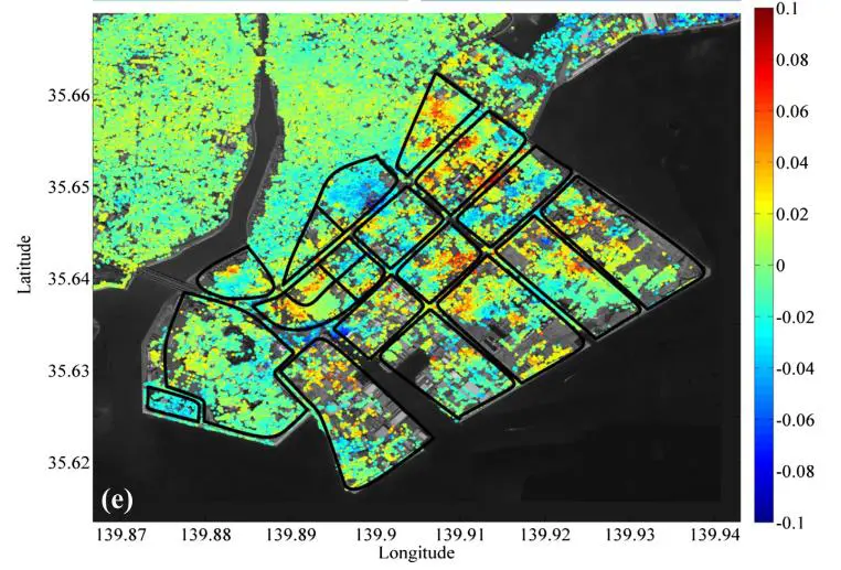
Multi-year deformation monitoring for infrastructure stability using Sentinel-1.
View Details →
Integrated GIS workflow for corridor planning and route evaluation.
View Details →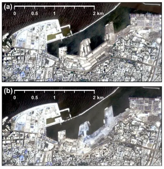
Multi-temporal satellite monitoring of urban expansion patterns.
View Details →Discuss your engineering requirements with our experts and get precise, reliable geospatial solutions.
Contact Us